|
20/11/2006
Iasmos bridge
The Iasmos bridge is the biggest stone bridge of Thrace, situated in the Kompsatos river, between the Iasmos and Polianthos village. Iasmos village is 40 m in altitude, 27 km away from Xanthi, 20 km away from Komotini. Iasmos’ population was 2.732 in 2001. Polianthos’ population is 794 inhabitants.
The bridge is five bowed, but its western end is destroyed (it is said that it was blown up during the Civil War). The decking’s length is in 62 m without the bow that is missing. If this bow existed the length would be in 70 m or over. The big bow is 21,50 m in length and 12.20 m in height. The eastern bow is 17 m in length and 9.80 m in height. You can see vents on the bows, because of the primary wooden construction. Big rocks are used at the parts that are on the rocks, while a kind of poop is shaped to protect the whole construction from the water’s stess. At the upper side, the road reminds us of the cobble roads with wide plain stones. Recent damaging of the bridge was repaired (October 2000) from the Revenue of Ancient and Byzantine Monuments.
The Iasmos bridge is believed to be post-Byzantine and that it was built in the foundations of an older one dated in second before Christ century. Egnatia Road was passing through Anastasioupolis and followed the direction of the contemporary motorway: Iasmos-Polianthos-Arisvi-Makri-Alexandroupolis. The planning and construction of the Egnatia road had was exceptional in avoiding unstable grounds and big grades. Usual inclines are between1%-2% and only in inaccessible areas they reach 18%-20%.
We meet other bridges too at Kompsatos river that impress us. Beginning form Thermes, we meet the big bridge of Medusa and another one as we move to Kotani. If we follow the pathway to Koundouros and Tsalapetinos, we will arrive at an imposing bridge with a central apse and two bows, after two hours walking. There are four more bridges at the Satres area: a recent construction outside the village, an old bridge in Satres, another one at the road to Akreos settlement and a little one at the road to the Temenos vill
|
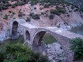 The Southwest side of the Iasmos bridge
 The Northeastern side of the Tichiro bridge
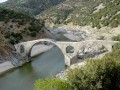 The two big bows of Iasmos bridge